Reprinted with permission from The Christian Science Monitor
Some breakthroughs seem to revolutionize our world overnight. Others, like laser mapping technology, take more of a slow build approach, inching into ubiquity while we're looking the other way.
Impatience led Chris Fisher to the discovery of a lifetime.
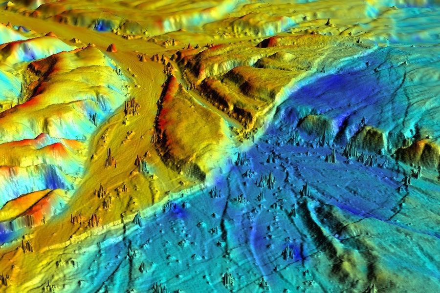 Researchers at the University of California Davis used 3-D lidar technology to construct this image of the Borrego Fault, which ruptured during the 2010 El Mayor-Cucapah earthquake in Baja California, Mexico. The various colors represented elevation changes during the earthquake.Courtesy of UC Davis
Like most archaeologists, he spent his days in the field plodding along on foot, perhaps hacking through jungles with teams of grad students and other scientists looking for pieces of ceramics or signs of ancient structures, mapping what they found as they went.
“There’s got to be a better way,” Dr. Fisher, an archaeologist at Colorado State University, recalls venting to a colleague, frustrated that in one year he could cover only a fraction of a square mile while surveying the ruins of Angamuco in west-central Mexico.
“There might be,” his colleague replied, “Have you heard of this thing called ‘lidar’?”
Lidar – short for light detection and ranging – is a scanning technology similar to radar, that can be used to reveal a sort of topographical map. Fisher decided to try it out. And sure enough, 45 minutes of airborne lidar in 2010 accomplished what would have taken at least a decade of traditional archaeology: a map of a city more extensive than anyone fathomed.
“I almost started crying,” Fisher recalls when he first saw the lidar map of Angamuco.
In the past decade or so, lidar has facilitated dazzling archaeological discoveries from medieval metropolises buried beneath the forests of Cambodia to small cities of a previously unknown culture in dense Honduras rainforest, a project of Fisher’s.
“Everywhere we point a lidar instrument, we find stuff,” he says.
Lidar isn’t actually an archaeological tool. Like it’s cousin, radar, it’s a technology that can be used quite universally – and it has facilitated breakthroughs across many fields. Lidar has been deployed in self-driving cars, weather forecasting, air quality assessments, space missions, atop wind turbines, to measure sea level rise, and after natural disasters to assess infrastructure damage. And it’s poised to become even more influential in the next decade.
“A tipping point in the public imagination stands right before us,” says Todd Neff, a writer whose latest book due out October 9, “The Laser That’s Changing the World,” explores the history of lidar. “It’s a really powerful, massively adaptable tool. It is the wheel. It is the hammer.” And as lidar gains publicity, he says, that will be increasingly recognized.
Since the first lidar prototype bounced a laser off an object in 1961, the technology has enabled scientists to observe and measure the world in new ways. The concept behind the technology is that if you measure how long it takes for the light to reflect back, you can calculate the distance of the object it bounces off, giving you a sort of inverse topography.
Atmospheric scientists seized on the new technology, as the precision of lasers allowed them to see the smaller particles, revealing things such as smoke, smog, and aerosols. The laser technology quickly took to space, too; NASA's Apollo missions used the instrument to map the lunar surface starting in 1971.
As laser technology developed and engineers began using a variety of wavelengths of light, lidar became a useful tool across even more disciplines. Lidar has been used to make archaeological maps, to construct virtual models of urban landscapes, to scan the ocean floor at some shallower depths, and to map changing coastlines and ice sheet melt. As long as light can penetrate anything between the lidar instrument and its target, it can be mapped.
After recent natural disasters, some cities were able to use comparisons of before and after lidar scans to assess which infrastructure needed the most attention. Government officials from Washington, D.C., to Utah have used lidar data to study things like flood plains, tree planting strategies, bike trails, and potholes.
“The use of the technology is definitely increasing,” says Craig Glennie, an assistant professor of engineering at the University of Houston and principal investigator at the National Center for Airborne Laser Mapping. “I think it’s always been increasing since it came about. It’s just that there started to be some very high-profile use cases of the technology” in recent years, and that has inspired others to try it. Archaeology is one field where breakthroughs from lidar have made a big public splash. Another is the development of autonomous vehicles.
Autonomous cars have been instrumental in driving the technology forward, Mr. Neff says. The sheer size of the market has spurred innovation and development of lower cost instrumentation. Self-driving cars as we know them today would not be possible without lidar, he says, as the use of the technology gives the vehicle an immediate view of its surroundings in terms of distance to objects.
Changes in the technology have happened quickly, says John Ristevski, chairman and CEO of CyArk, a company that uses lidar to create digital models of historical monuments around the world to facilitate restoration in case of damage. He also formerly worked with lidar for autonomous vehicles.
When Dr. Ristevski first started using lidar as a graduate student in 2001, a lidar scanning device was large, heavy, and cumbersome, and he recalls that it would’ve cost a couple hundred thousand dollars. “Now it’s a much more accessible technology across the spectrum,” he says, as some lidar instruments can cost just hundreds of dollars now, largely due to the autonomous vehicle industry.
Cost reductions have facilitated more uses of the technology, which in turn has motivated development of more nuanced, specialized, and efficient lidar systems. “It’s a feedback loop,” says Joe Shaw, director of the Optical Technology Center at Montana State University.
Professor Shaw is familiar with that loop, as colleagues have approached him about working together to try new applications of lidar, some of which have required the engineer to tinker with the technology to make an instrument suited for more specific uses.
For example, an entomologist asked Shaw if he could perhaps track honeybees using lidar. The scientist was working to see if honeybees could be used to detect buried landmines and he needed a way to monitor them. It was a particular challenge, Shaw says, because tall grasses were obscuring the insects as they foraged. To resolve the problem, Shaw developed what he has called “wing beat modulation lidar,” which can sort out an insect from blades of grass swaying in the wind by detecting the changing angle of its wings as it flies.
“It’s an interesting window into human creativity and scientific creativity, if you look at the breadth of the applications and the way people have decided to use it in totally different ways,” Neff says.
And lidar appears set to continue on its path to ubiquity.
“I would be overly ambitious if I said there were no limits,” to how lidar can be used, Shaw says. “But I absolutely think there are still new applications to which we have not yet applied lidar.”
Page created on 10/9/2018 5:33:18 AM
Last edited 10/9/2018 5:50:51 AM